TOTAL PAGEPREVIEW

HISTATS

Monday, July 30, 2012

Shivapuri Nagarjun National Park

Shivapuri Nagarjun National Park is the ninth national park in Nepal and was established in 2002. It is located in the country's mid-hills on the northern fringe of the Kathmandu Valley and named after Shivapuri Peak of 2,732 m (8,963 ft) altitude. It covers an area of 159 km2 (61 sq mi) in the districts of Kathmandu, Nuwakot and Sindhupalchowk, adjoining 23 Village Development Committees.

History

The area has always been an important water catchment area, supplying the Kathmandu Valley daily with several hundred thousands cubic liter of water. In 1976, the area was established as a protected watershed and wildlife reserve. In 2002, it was gazetted as Shivapuri National Park, initially covering 144 km2 (56 sq mi), and extended by the Nagarjun Forest Reserve in early 2009 to its present size.

Makalu Barun National Park

The park and conservation area is situated in the Sankhuwasabha and Solukhumbu districts, bordered by the Arun River on the east, Sagarmatha (Mt. Everest) National Park on the west, the Nepal-Tibet border on the north and Saune Danda (ridge) to the south. The Park covers 2,330 sq. km.This is the only protected area in Nepal with designation of a Strict Nature Reserve. It has some of the richest and most unique pockets of plants and animals in Nepal, elsewhere lost to spreading human habitation. Stepping up the slopes are a series of vegetation zones starting with tropical sal forest below 1,000 m. elevation: subtropical schimawalchhi forest at 1,000-2000 m. fir, birch, rhododendron forests in the sub-alpine (3,000-4,000 m); and herbs, grasses and rhododendron/juniper shrubs in the alpine pas trues (4,000-5,000 m). 
 
There are 47 varieties of orchids, 67 species of bamboos, and 15 oaks including Arkhoulo, 86 species of fodder trees and 48 species of primrose. Over 400 species of birds have been sighted in the Makalu-Barun area, including two species never before seen in Nepal the spotted wrenbabbler and the olive ground warbler. Wildlife includes the endangered red panda, musk deer, Himalayan black bear, clouded leopard and possibly snow leopard, in addition to more substantial populations of ghoral, thar, wild boar, barking deer, Himalayan marmot and weasel, common langur monkey and the serow. The Arun river system contains 84 varieties of fish.

Entry Fee:
  • For Nepalese Nationals, Free
  • For SAARC Nationals, Rs. 100/- per person
  • For Other Foreign Nationals, Rs. 1,000/- per person

Access:
  
To reach Makalu-Barun National Park & Conservation Area, take the daily flight from Kathmandu to Lukla, Phaplu, Lamidanda, Bhojpur and Tumlingtar. Visitors choice to fly any one-air link airports then trek or drive by private vehicle or public bus to Dhankuta Hile.

Khaptad National Park

Khaptad, Nepal's newest park area, is in the middle hills of the Far-West of the country. The 225 sq kms. area of the park is situated where the districts of Bajhang, Bajura, Doti and Achham meet. Khaptad is plateau of grassland and forest cover at an elevation of about 3,000 meters. The mixed conifer and broad-leaf forests are an excellent example of the vegetation that once covered much of west Nepal's middle hills. The forest consists of a mixture of tall fir, yew, rhododendron, oak, dense strands of bamboo and smaller shrubs. This habitat provides good cover for bear, leopard, barking and musk deer, as well as birds like the Impeyan, koklas and kalij pheasants.  
This park is special because it represents one of the few remaining mid-mountain ecosystems in Nepal Himalaya. At the north-eastern corner of the park, a small serene lake and swampy area called Khapted Daha is religious site where Hindu pilgrims come to worship Shiva on the full moon of July-August each year. Here lived the ascetic, the Khaptad Baba, who was known and revered throughout Nepal.

Entry Fee:
  • For Nepalese Nationals, Free
  • For SAARC Nationals, Rs. 100/- per person
  • For Other Foreign Nationals, Rs. 1,000/- per person

Access:
 
The easiest access is to fly to Dipayal or Chainpur or Sanfebagar or Kolti from where it is a few days hike to the national park. It is also possible to drive to Silgadi from Dhangadi. The best time to visit Khaptad is in March and April and in October and November. Is the best season to visit this area the travelers also organize the camping trek also.

Shey Phoksunda National Park


Much of the park lies north of the Great Himalayan Range. Kanjiroba Himal lies at the southern edge of the trans-Himalayan region of the Tibetan plateau. The high Dolpa plateau in the northeast of the park is drained by the Langu (Namlang) River. The southern catchment of the park is drained by the Jugdula and Suligad Rivers, which flow south and drain into the Bheri River. Nepal's second largest lake, Phoksundo, lies at 3660 m in the upper reaches of Suligad.

Vegetation and Animals:
  • The vegetation found in the park is diverse due to the influence of two different micro-climates. The southern river valleys along Suligad contain luxuriant forests mainly comprising blue pine, spruce, cypress, poplar, deodar, fir and birch. The Jugdula River valley consists mostly of Quercus species. The trans-Himalayan area has a near-desert type vegetation comprising mainly dwarf juniper and caragana shrubs.
  • The park provides prime habitat for snow leopard and blue sheep. The blue sheep are mainly concentrated around Shey Gomba and Dolpo. Other common animals found in the park are: goral, Himalayan tahr, serow, leopard, wolf, jackal, Himalayan black bear, Himalayan weasel, Himalayan mouse hare, yellow-throated marten and langur and rhesus monkeys.
  • The park is equally rich in birds. The commonly seen birds are Impeyan pheasant (danphe), blood pheasant, cheer pheasant, red and yellow-billed choughs, raven jungle crow, show partridge and many others.
Seasons:
  • Spring season (March-May) usually has fine weather although high passes still remain covered with the winter snow. Being located behind the main Himalayan range, the park is little affected by monsoon rain from June until September and weather usually remains clear. The alpine flowers are at their best color during the months. The winter temperatures drop below 0 C. Occasional heavy snowfall in mid-winter closes the trails for several days.
Local Communities:
  • There are several settlements in the park, totaling an approximate population of 2000. The peoples lifestyle and culture are still strongly reminiscent of Tibet. Local inhabitants believe in the Buddhist religion but the community of Phoksundo area practices Bon, a pre-Buddhist sect. Almost all villages have their own communal gompas.
  • The local economy is heavily based on agriculture, growing mainly potatoes, buckwheat, mustard, beans and some barley. Animal husbandry is a main source of food and wool for weaving clothes. Trading is done with Tibet, exchanging food grains for salt and wool.
Tourist Attraction:
  • Shey is interesting for religions and wildlife. Phoksundo Lake also known as Ringmo Lake, it is the most interesting site of the park. The lake is drained by a waterfall from a height of nearly 150 m making it the highest waterfall in the country.
  • There are a few Buddhist monasteries near the lake in Ringmo and Pugmo villages.
How to Get There:
  • The easiest and shortest route to reach the park is to fly to Juphal airstrip in Dolpa from Nepalgunj or Pokhara. From there, it is an easy one day walk to reach the park guardpost at Suligad and three days walk to reach park HQ. at Sumduwa.
  • Alternate routes are to fly to Jumla and trek about 10 days to the Phoksundo and Shey areas.. An adventurous route begins in Dhorpatan crossing several high passes before reaching Dunai, the District HQ. of Dolpa.
Important Points:
  • Flora and fauna are fully protected and must not be disturbed.
  • Visitors should be self-sufficient in fuel supply entering the park. Use of firewood is strictly prohibited.
  • Rubbish must be buried or disposed of in a designated place.
  • Movement in the park between sunset and sunrise is prohibited.
Entry fees into Shey Phoksundo National Park:

All visitors must pay a park entry fee at Ankhe guard post of park HQ.
  • Natrional Park fees per person per entry:
  • For Nepali Nationals Free
  • For SAARC Nationals Rs 100
  • For Foreign Nationals Rs 1000
  • Children under 10 years Free
  • Be sure to keep your entry permit as it might be checked later by park personnel.

Sagarmatha National Park

Sagarmatha National Park covers an area of 1148 square kilometers in the Khumbu region of Nepal. The Park includes the highest peak in the world. Mt. Sagarmatha (Everest 8848 m.) and several other well known peaks such as Lhotse, Cho Oyu, Pumori, Ama Dablam, Thamerku, Kwangde, Kangtaiga and Gyachyung Kang.
As Mt. Sagarmatha and the surrounding area is of major significance not only to Nepal but to the rest of the world, its status as a national park since 1976 is intended to safeguard its unique cultural, physical and scientific values through positive management based on sound conservation principles.

Geology:
  • According to the continental-drift theory, the Himalaya were uplifted at the end of the Mesozoic Era, some 60 millions years ago. The resulting young mountains of this region are still rising and the net growth is a few centimeters per century.
Vegetation, Wild Animals and Birds:
  • Vegetation in the park varies from pine and hemlock forests at lower altitudes, fir, juniper, birch and rhododendron woods at mid-elevations, scrub and alpine plant communities higher up and bare rock and snow above tree line. The famed bloom of rhododendrons occurs during the spring (April and May) although much of the. flora is most colorful during the monsoon season (June to August). .
  • The wild animals most likely to be seen in the park are the Himalayan tahr, goral, serow, musk deer and Himalayan black bear. Other mammals are weasels, martens. Himalayan mouse hare (Pika), jackals and langur.
  • The park provides a habit for at least 118 species of birds. The most common birds to be seen are the Impeyen pheasant (the national bird of Nepal), blood pheasant, cheer pheasant, jungle crow, red billed and yellow billed coughs and snow pigeon. Fairly common birds are the Himalayan griffon, lammergier, snow partridge, skylark and many others.
Seasons:
  • The summer climate is cool and wet and winter is cold and dry. Almost all of the annual precipitation, averaging less than 1000 mm, falls during the summer monsoon, from end of May to September. Climatically, the best time to visit the park is between October and May, except for December to February when, daytime temperatures often drop below 0 C and there is heavy snowfall.
Local Inhabitants:
  • The park is populated by approximately 3000 of the famed Sherpa people, originating from Tibet in the late 15th or early 16th century A.D. Their lives are interwoven with the teaching of Buddhism. The main settlements are Namche Bazaar, Khumjung, Khunde, Thame, Thyangboche, Pangboche and Phortse. There are also temporary settlements in the upper valleys where the Sherpas graze their livestock during the summer season.
  • The economy of the Khumbu Sherpa community has traditionally been agriculture, livestock herding and trade with Tibet. With the coming of international mountaineering expeditions in the 1950s, the region also attracted larger numbers of foreign trekkers. Today the Sherpa economy is becoming increasingly dependent on tourism.
How to Get There:
  • Fly in and out of Lukla, followed by 15 days walk.
  • Bus to Jiri and trek for 21 days, flying back to Kathmandu from Lukla.
  • Fly in and out of Phaplu and trek for 16 days.
  • Fly in to Tumlingtar from Kathmandu and a 10 day walk to the park.
Important Points:
  • There are trekker lodges with food available in places like Namche Bazaar, Thyangboche, Pheriche and Lobuche and along most of the main trekking routes the small villages have basic accomodation.
  • There is the Himalayan Rescue Association (HRA) at Pheriche which has medical facilities and also accepts credit card as payment.
  • The National Park ranges from 3000 m to 8000 m and above in altitude. Visitors need to be careful and aware of High Altitude sickness (HAS). Do not climb to fast or too high in one day, no more than 400 m in a day. Signs of HAS include: headache, difficulty in sleeping, breathlessness, loss of appetite, nauseousness and general tiredness.
Entry Fees into Sagarmatha (Everest) National Park:
At Monjo there is the Sagarmatha National Park enterance station where you will have to show your passport and pay a National Park fee.
  • National Park fee per person per entry:
  • For Nepali Nationals Free
  • For SAARC Nationals Rs 100
  • For Foreign Nationals Rs1000
  • Children under 10 years Free

Wednesday, July 25, 2012

Langtang National Park

Langtang is one of the most unspoiled national parks of Nepal. Situated North of Kathmandu, it is the most easily accessible highland sanctuary from the capital. Langtang covers 1,710 sq. km. forming the upper catchment areas of two of Nepal's largest river systems - the Trishuli and Koshi. There is great latitudinal variation, starting at 1,500 m. and ascending to the top of Mt. Langtang Lirung at 7,234 m. As a result the park has immense ecological diversity. Some of the most attractive areas of the park include the Langtang Valley, the holy lakes at Gosainkunda, and the forested hillsides above the village of Helambu.
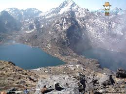
The deep gorges of Bhote Koshi and Langtang Khola are thickly forested with rhododendron, oak, maple and alder. The stretch of forest around Ghoda Tabela in the lower Langtang Valley and below Gosainkunda is inhabited by the red panda, a rare and threatened symbol of a healthy Himalayan ecosystem. Other animals, common to these forests are wild boar, Himalayan black bear, ghoral, grey langur monkey and leopard. The rare Himalayan hony guide has been sighted here and the park is also the home for Impeyan, Tragopan and kalij pheasants among others. Larch, a rare deciduous conifer, is also found in the forest of lower Langtang Valley. Further up, Himalayan tahr, musk deer and snow leopard can be found. The upper Langtang Valley is one of he few known breeding grounds of the ibils bills besides the Tibetan snow cock and snow partridge.
Like other Himalayan nature parks, Langtang has to be explored on foot. There are several possible trails to choose from depending on preference and time available. The langtang Valley is easily approached from Dhunche town and park office, which is a day's drive from Kathmandu. The upper reaches of Langtang can be reached in four days of easy walking, however, it is advisable to spend a few days around the forest at Ghoda Tabela to watch for the red panda. Once above Langtang village and the monastery at Kyangin, visitors can explore the high valley of Langshisa Yala peak and Tsero, Ri. These and other villages of upper Langtang are inhabited by people of Tibetan descent whereas the villagers of Dhunche, Bharkhu and Syabru further down are home to the Tamangs of Nepal's middle hills.

Entry Fee:
  • For Nepalese Nationals, Free
  • For SAARC Nationals, Rs. 100/- per person
  • For Other Foreign Nationals, Rs. 1,000/-per person
  • (Note: Entrance fee not required for children under 10 years).

Access:
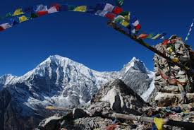
The high pass out of Langtang, Gang la(5,132m), can be negotiated only by well prepared hikers with guides, food and camping equipment. The Gosainkunda can also be reached in a few days from Dhunche, making it possible to visit both areas in the same outing.
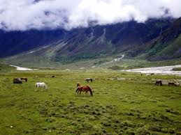
Alternatively, trekkers can hike to Gosainkunda from Sundarijal in the Kathmandu Valley via the picturesque villages of Helambu. The richly forested route that climbs steeply from here to Thare Pati and Gopte Cave is alive with birds and flowering rhododendron and orchids in the spring. Tourists can visit the Langtang National Park anytime from March to November but it is best to avoid the monsoon season because of rains and overflowing rivers. The nature enthusiast on the other hand might find the rainy season ideal because of the profusion of plant life.

Monday, July 23, 2012

Chitwan National Park

Royal Chitwan National Park stands today as a successful testimony of nature conservation in South Asia. This is the first national park of Nepal established in 1973 to preserve a unique ecosystem significantly valuable to the whole world. The park covering a pristine area of 932 sq. km is situated in the subtropical inner Terai lowlands of southern central part of Nepal. The park has gained much wider recognition in the world when UNESCO included this area on the list of World Heritage Site in 1984.
Formerly, the Chitwan valley was well known for big game and was exclusively managed as a hunting reserve for the Rana Prime Ministers and their guests until 1950. In 1963, the area south of Rapti was demarcated as a rhinoceros sanctuary. In 1970, His late Majesty King Mahendra had approved in principle the creation of Royal Chitwan National Park.
The park consists of churia hills, ox-bow lakes, flood plains of Rapti, Reu and Narayani rivers. The Churia hill rises gradually towards the east from 150 m to over 800 m. The lower but most rugged Someshwor hills occupy most of the western portion of the park. The flood plains of Chitwan are rich alluvial. The park boundaries have been delineated by the Narayani and Rapti rivers in the north and west, and the Reu river and Someshwor hills in the south and south-west. It shares its eastern border with Parsa Wildlife Reserve.

Vegetation and Animals:
  • The Chitwan valley is characterized by tropical to subtropical forest. 70% of park vegetation is predominantly Sal ( Shorea robusta ) forest, a moist deciduous climax vegetation type of the Terai region. The remaining vegetation types include grassland (20%), riverine forest (7%) and Sal with Chirpine ( Pinus roxburghii ) (3%), the latter occurring at the top of the Churia range. The riverine forests mainly consists of khair, sissoo and simal. The simal is with spiny bark when young and develops buttress at the bottom in older stage. The grasslands form a diverse and complex community with over 50 species. The Sacchrum species, often called elephant-grass can reach 8 m in height. The shorter grasses such as Imperata is useful for thatch roofs.
  • There are more than 43 species of mammals in the park. The park is specially renowned for the protection of the endangered one-horned rhinoceros, tiger, gharial crocodile along with many other common species of wild animals. The estimated population of endangered species of animals such as gaur, wild elephant, four horned antelope, striped hyena, pangolin, gangetic dolphin, monitor lizard and python, etc.
  • Some of the other animals found in the park are samber, chital, hog deer, barking deer, sloth bear, common leopard, ratel, palm civet, wild dog, langur, rhesus monkey, etc.
  • There are over 450 species of birds in the park. Among the endangered birds found in the park are Bengal florican, giant hornbill, lesser florican, black stork and white stork, Few of the common birds seen are peafowl, red jungle fowl, and different species of egrets, herons, kingfishers, flycatchers and woodpeckers. The best time for bird watching is March and December.
  • More than 45 species of amphibians and reptiles occur in the park and some of which are marsh mugger crocodile, cobra, green pit viper and various species of frogs and tortoises.
  • The park is actively engaged in the scientific studies of several species of wild flora and fauna.
Seasons:
  • The park is under the tropical monsoon climate with relatively high humidity. The winter, spring and monsoon are the three main seasons. The cool winter season occurs from October to February. The spring begins in March and is soon followed by summer that ends in early June. The summer days are typically hot with 30 C on average day temperature. The monsoon usually begins at the end of June and continues until September. The mean annual rainfall is about 2150 mm and during this time of the year rivers are flooded and most of the roads are virtually closed.
How to Get There:
  • The park is accessible by car or bus on the Kathmandu-Mugling-Narayanghat Highway and or through Mahendra Rajmarg Highway from Hetauda. It is about 6 hour's drive from Kathmandu to Narayanghat. Local buses are available to Tadi Bazar which is about an hour drive form Narayanghat. A 6 km walk or bullockcart ride brings the visitors to Sauraha, the park entrance. Also air services from Kathmandu to Meghauli for US$82 each way and Bharatpur US$65 each way are available. Local buses are available form Narayanghat to Park HQ. Kasara.
Park Facilities:
  • Display Center, Kasara
  • Library at Kasara Sauraha
  • Visitor Center, Sauraha
  • Machans (View tower)
Activities:
  • Elephant ride
  • Canoeing
  • Guided jungle walk
  • Terai culture
  • Wildlife breeding projects
  • 4WD safaris
Enrty fees into Royal Chitwan National Park:
  • National Park entry fee per person per day:
  • For Nepali Nationals Rs 20
  • For SAARC NAtionals Rs 200
  • For Foreign Nationals Rs 500
  • Children under 10 years Free
  • Elephant ride for about 2 hrs. - Rs 550 - (Nepali's Rs 100)
  • Fishing permit - Rs 300 - (Nepali's Rs 20)
  • Camping per night per person - Rs 300 - (Nepali's Rs 20)
  • Guided jungle walk - Rs 250/400 for half day/full day - (Nepali's Rs 20)
  • Canoeing - Rs 230 per person
  • 4WD safari - Rs 650 per person
  • Gharial crocodile breeding centre - included in the park entrance fee
  • Elephant breeding centre - included in the park entrance fee
  • Lodges offer all-inclusive packages for 2 to 4 days for those who want everything pre- organised by the lodge guides.

Twitter Delicious Facebook Digg Stumbleupon Favorites More

 
Design by Free WordPress Themes | Bloggerized by Lasantha - Premium Blogger Themes | Powerade Coupons